 Colliers Insights Team
The figures are still being calculated for the costs of Hurricane Sandy, which swept up the East Coast of the United States in the fall of 2012, but at the moment they stand at $68 billion. That makes Sandy the second costliest hurricane in the nation’s history. Hurricane Andrew, which ripped across Florida and then crossed the Gulf of Mexico to Louisiana in 1992, caused $40 billion in damages, while Ike in 2008, Rita in 2005, Wilma in 2005, Charley in 2004 and Ivan in 2004 all cost a combined $91 billion. Hurricane Katrina, the devastating Category 5 storm of 2005, holds its place as the single most costly weather disaster in American history at $138 billion.
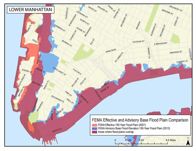
This FEMA map produced two years ago compares 2007 and 2013 flood plains in lower Manhattan.
Most of the damage wrought by those storms came not from wind and flying debris, which are the sorts of things that can be guarded against with plywood and duct tape, but instead by storm surges and inland flooding. The trends indicate that these are increasing in intensity and reach because of a global pattern of climate change whose hallmark feature, besides climbing temperatures and melting Arctic ice caps, is a rise in sea levels around the world. Climatological forecasts vary widely, but many posit that sea levels will be anywhere from 1 to 8 feet higher than at present by the year 2100, affecting billions of people and entailing costs that could rise into trillions of dollars. Meanwhile, more than half of the population of the United States lives near the ocean coasts and Great Lakes. And by all accounts, that percentage is likely to rise in the coming decades.
It’s for all those reasons that on Jan. 30 President Obama issued an Executive Order requiring all federal agencies employ strict building standards that take into account the likelihood of future flooding. The order follows a report from the U.S. Army Corps of Engineers that warns that increased flooding is likely on the Atlantic and Gulf coasts, as well as the National Climate Assessment‘s findings that at least one trillion dollars of property damage will ensue from flooding brought about by a 2-foot rise in sea level – something that many climate models assume will happen sooner rather than later.
The Executive Order allows agencies three options in determining how to measure flood elevations and hazard areas in siting and building federal projects. The first assesses them using the “best available, actionable hydrologic and hydraulic data and methods that integrate current and future changes in flooding based on climate science.” The second adds anywhere from 2 to 3 feet to the current baseline of the so-called 100-year flood elevation (that is, the high water mark for major floods that, in theory, occur only once a century but in practice happen more often), the lower figure for ordinary structures and the higher one for “critical” buildings such as VA hospitals, military installations and the like. The third defines the floodplain as the “area subject to flooding by the 0.2 percent annual chance flood,” which is the area inundated not by a 100-year but a 500-year flood.
These options are clearly open to some degree of interpretation, as is the wrinkle that an agency head can make exceptions to the order if the project is a “mission-critical requirement related to a national security interest or an emergency action.” In some instances, local codes for new buildings are more stringent than those of the federal government — even with these changes. In any event, the new regulations have no effect on existing structures and infrastructure that are increasingly more vulnerable to flood damage.
To all of these, concerns are sure to arise about the costs that will be added to projects as a result of the order, even if they lead to future savings in avoided damage. Thus was the case when GSA initially implemented seismic policy that, in effect, rendered huge numbers of federally leased buildings functionally ineligible to renew their longtime tenants. Similarly, GSA’s early attempts to convert the Energy Independence and Security Act into leasing policy were fraught with unintended consequences that, ironically, limited the ability of the newest and most energy efficient buildings to compete for federal tenants.
We know from practical experience from managing leases across the nation that even minor changes to GSA’s interpretation of flood plain maps could adversely impact many buildings currently leased by federal tenants. We’ll be watching as policy is developed around this presidential mandate. The annals of government are full of well-intended laws and Executive Orders that have been drowned by burdensome policy. It remains to be seen whether President Obama’s latest Executive Order will be one of them.
Kurt Stout is the national leader of Colliers International’s Government Solutions practice group, which provides government real estate services to private investors and federal agencies. He also writes about federal real estate on his Capitol Markets team blog. You can contact Kurt by email or on Twitter.


 Coy Davidson